
Challonsleigh / Devon / Case study
Planning permission secured /Challonsleigh
waste & restoration.
Waste infrastructure. Phased land restoration. Planning permission secured through one connected strategy.
- 01Inert landfill & restoration
- 02Waste transfer & recycling
- 03Settlement ponds
- Client

- DDE (SW) Ltd
- Dorton Group
- Dorton Demolition & Excavation Ltd
- Location / Reference
- Challonsleigh / Devon
DCC/4038/2018 - STAGE role
- Project leadership, planning strategy and consultant coordination
- Planning outcome
- Permission granted 1 April 2020
- Proposed inert-landfill capacity
- ~585k m³Capacity set out in the 2017 statement
- Proposed landfill area / hectares
- 16.25Alongside the existing waste operation
- Proposed landfill phases
- 4Sequenced filling and restoration
- 01 / Connected scope
Recovery & recycling
A permanent waste-transfer station for the expanded operation
- 02 / Connected scope
Inert landfill
A phased facility for material that could not be recycled
- 03 / Connected scope
Land restoration
A planned return to agriculture after the temporary operation
The asset / Opportunity
An operational site. A much wider land strategy.
Challonsleigh Farm lies south of the A38 at Smithaleigh, near Lee Mill in Devon. Dorton Group’s existing recycling operation sat within a wider rural holding, with agricultural fields to the north and the River Yealm corridor nearby.
The proposal connected two different development requirements: a permanent waste-transfer and recycling facility on the operational site, and a temporary inert landfill to its north. The future use of the land had to be considered alongside the operation from the outset.
The client objective
Make recovery, residual disposal and restoration work together.
The client sought to expand the existing operation to accept and sort construction and demolition materials, with a processing building, hardstanding, weighbridge, offices and welfare facilities. Residual inert material that could not be recycled would be placed in the adjoining landfill.
The landfill proposal was temporary and phased, with restoration to agriculture forming part of the design. The planning case therefore needed to explain the facility’s working life and the landscape it would leave behind.
The challenge
A complex operation in a sensitive landscape.
The waste-transfer station and landfill had different operational lives, physical requirements and environmental relationships. Vehicle circulation, processing space, site levels, drainage, screening and future restoration could not be resolved independently.
The river corridor, floodplain, woodland, neighbouring uses and access to the A38 all informed the proposal. Devon County Council’s screening process required an Environmental Statement, bringing transport, landscape, ecology, flooding, historic environment, operational amenity and aftercare into the same assessment.
What was at risk
The commercial position behind the planning question.
Operational viability
The processing building, weighbridge, circulation and hardstanding needed to form a practical working facility rather than a collection of separate design decisions.
Environmental dependencies
Landform, drainage, screening and the relationship with the River Yealm needed to be understood before the operational footprint was fixed.
The land’s future
Phasing and aftercare needed to connect the temporary landfill operation with a credible restored landscape and agricultural use.
The STAGE strategy
Intelligence.
A coordinated route.
Planning leads the strategy. Design, site intelligence and specialist evidence develop together around the asset and the client’s decision.
Define the whole operation
Connect the existing recycling use, expanded material recovery and proposed inert landfill. Distinguish the permanent waste infrastructure from the temporary landform works.
Resolve the working site
Bring the processing building, one-way circulation, weighbridge, supporting facilities, access and water management into one operational layout.
Design the land’s future
Plan the landfill in four phases, relate the landform to the river corridor and coordinate bunds, drainage and planting with the restoration sequence.
Coordinate the EIA workstreams
Bring design, transport, landscape, ecology, water management and operational amenity evidence into a coherent environmental and planning case.
The technical record
From the working yard to the final landform.
These actual design and application drawings connect the operational layout with the proposed landform, building, visibility and lighting. Explore the complete engineering sheets behind the planning case.
The drawing record 07 sheets
- View original sheet
- View original sheet
- View original sheet
- View original sheet
- View original sheet
- View original sheet
- View original sheet
Select a drawing to explore the proposal. Every original sheet remains available at full resolution.
The whole site
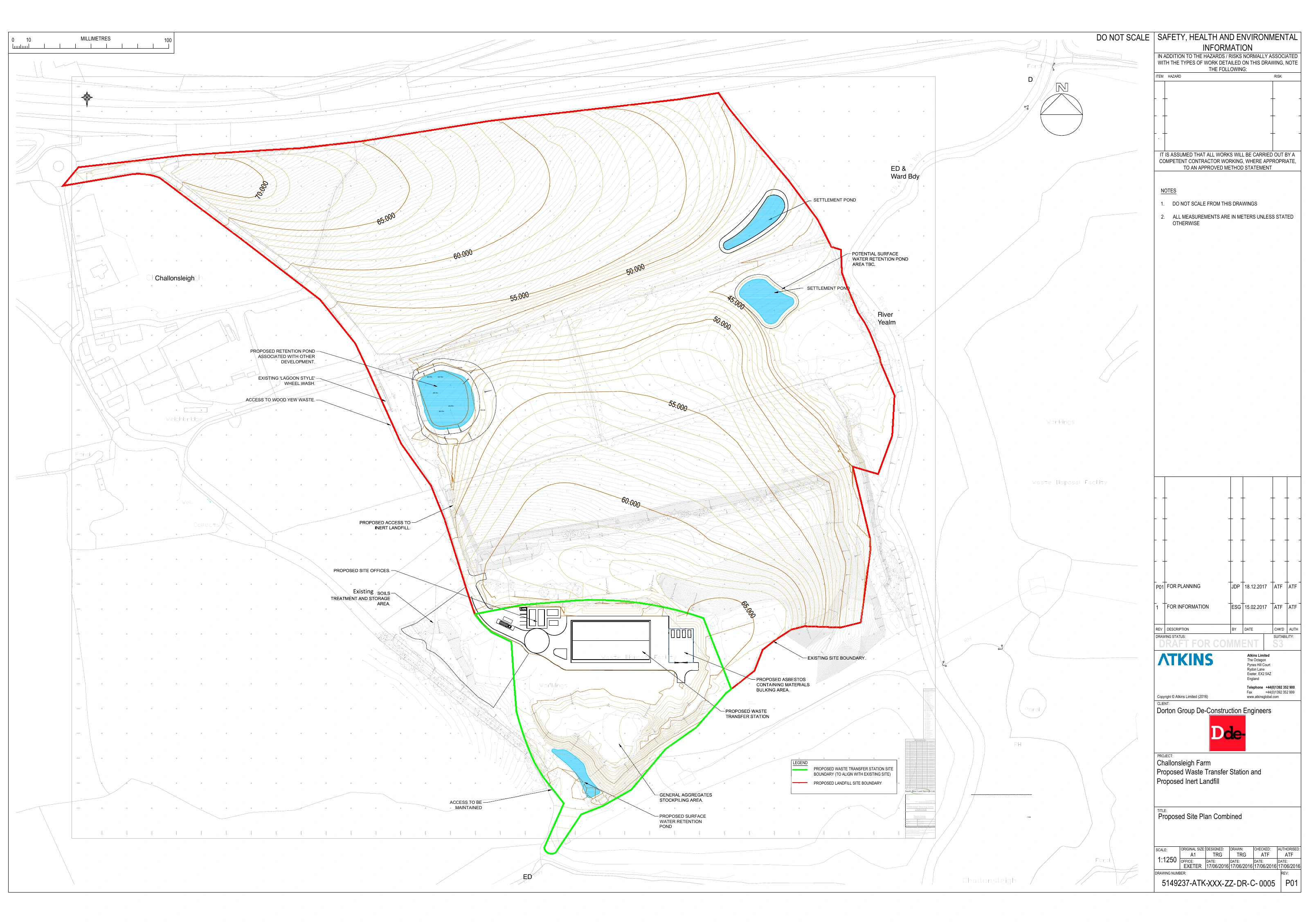
The combined plan connects the proposed inert landfill with the waste-transfer facility, existing operations and surface-water infrastructure.
Atkins / 18 December 2017 / Proposed designDesign development and application drawings / 2017–2018. Atkins. Original colours, references, title blocks and design-status notes retained. These records show proposed works; they are not construction-completion records.
The team
One strategy.
One team.
One point of contact.
STAGE led the project and planning application for the Dorton client group. Janine Banks prepared the December 2017 Design and Access Statement, bringing the operational brief, site context, design response, access and restoration strategy into a connected planning narrative.
The multidisciplinary team brought engineering and environmental expertise into that strategy. The statement references Atkins and Aspect on landscape and visual matters, and WSP on flood-risk and ecological reporting. The engineering drawings reproduced here are by Atkins.
- Project leadership & planning / STAGE
- STAGE led the project and planning application. The Design and Access Statement, prepared by Janine Banks, explains the relationship between the operating brief, proposed layout, access and restoration.
- Engineering & design / Atkins
- Combined site planning, waste-transfer layout and building design, long sections, visibility testing and external lighting are shown in the supplied drawing record.
- Landscape & restoration / Aspect
- The statement references landscape and visual work and the restoration programme, connecting screening and planting with the phased landform.
- Water & ecology / WSP
- Flood-risk and ecological reporting inform the proposal’s relationship with the river corridor, drainage, habitat and environmental mitigation.
Documented output
A planning case across two connected facilities.
The Design and Access Statement sets out the permanent waste-transfer station and temporary inert landfill as parts of one wider proposal. The engineering record develops that relationship through site plans, sections, building drawings, visibility studies and lighting layouts.
STAGE led the route through the planning process, connecting the facility’s working requirements with the environmental evidence and long-term restoration strategy.
The next stage
A strategy for the operation and the land beyond.
The permission established a planning route for the proposed facilities and associated works. The drawings explain the design development and application record; later conditions and implementation milestones will be added as they are confirmed.
For complex waste and operational-land projects, that wider perspective matters: the next building, the movement of materials and the eventual use of the land need one coordinated route forward.
Discuss your land or asset